(DETAILS DESCRIBED BELOW ARE VISIBLE IN THE original SIZE IMAGE)
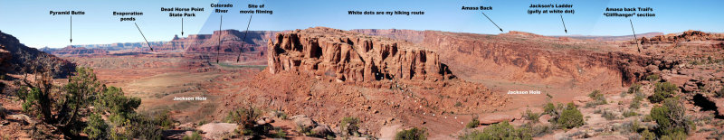
Straight ahead is the broken, eroded east "face" of Jackson Butte; I am headed there to see
how far into the butte I can get on foot. The valley below---Jackson Hole---is an abandoned
meander of the Colorado River. The muddy Colorado River is flowing from right to left.
Pyramid Butte and the evaporation ponds of the potash mine are featured in another gallery.
The mesa in the distance, to the right of and about three miles behind the tower, is the site of Dead Horse Point State Park.
The end of the railroad spur at the mine was the site in 1983 of filming of a scene from a movie.
Amasa Back is a ridge inside a U-turn in the Colorado River.
Jackson's Ladder is a rough trail that descends a rocky gully, linking the Amasa Back Trail with the road in Jackson Hole.
Off to the right, the trail runs along the precipice above Jackson Hole; this is called "The Cliffhanger" by some.
This is a merging of five hand-held images.
.