


|
|
|
|
|
|
| |
| 24-OCT-2007 | © DK Hein 2007 |
Submitted as a companion image for the
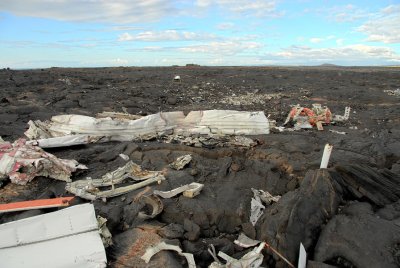
Thursday 10/25/07 Totally Informal Transglobal Challenge. Topic: “Dereliction”
For other entries, see: http://forum.pbase.com/viewtopic.php?t=34235
This can also be seen on Google Maps or Google Earth (best) at 19.7586N, 156.0417W.
(In Google Maps click either Satellite or Hybrid & adjust the zoom level.)
At the time of the accident the runway was 4,500 ft shorter than it is now, meaning
this plane came down approximately 1.2 miles before it should have.
© 2017 DK Hein, All Rights Reserved.
| comment | |
| yannick Beunard | 10-Nov-2007 08:56 | |
| Jose Canovas | 26-Oct-2007 22:11 | |
| Guest | 26-Oct-2007 01:59 | |
| Guest | 25-Oct-2007 18:38 | |
| Guest | 25-Oct-2007 18:09 | |
| Alida Thorpe | 25-Oct-2007 18:03 | |
| Guest | 25-Oct-2007 16:37 | |
| beverley harrison | 25-Oct-2007 11:01 | |
| Barry S Moore | 25-Oct-2007 10:43 | |
| Dave Hein | 25-Oct-2007 10:27 | |
| Ian York | 25-Oct-2007 10:10 | |
| Barry S Moore | 25-Oct-2007 10:09 | |
| Jola Dziubinska | 25-Oct-2007 09:54 | |
| Barbara Heide | 25-Oct-2007 09:50 | |
| Máire Uí Mhaicín | 25-Oct-2007 09:26 | |