This image is a William A. Fishbaugh photograph donated to the Florida State Archives. I cropped and enhanced it for website display.
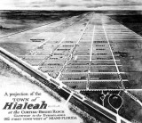
This is the projection for the Town of Hialeah at the Curtiss-Bright Ranch, looking due north with County Road (later Okeechobee Road) at the bottom. The moving pictures studio is at the intersection of W. 2nd Avenue (Opa-locka Avenue on the map) and 9th Street. I can't tell what W. 1st Avenue is named because of a backwards "n" in the first name (Cnil Lock Avenue?). E. 1st Avenue was "Seminole Avenue" and E. 2nd Avenue was "Eucalyptus Avenue."
I'm fairly sure that the developers didn't plan for all the horrid and ugly zoning decisions to be made by Hialeah's numerous city councils over the next eight decades.