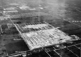
photo sharing and upload picture albums photo forums search pictures popular photos photography help login
Don Boyd | all galleries >> Memories of Old Hialeah, Old Miami and Old South Florida Photo Galleries - largest non-Facebook collection on the internet >> 1950 to 1959 Miami Area Historical Photos Gallery - click on image to view > 1957 - Aerial view of Bird Road and SW 117 Avenue area
previous | next
1957 ID captions by Don Boyd

1957 - Aerial view of Bird Road and SW 117 Avenue area

Southwest Dade County, Florida


The view is looking east-south-east. Westwood Lake is in the middle and the development has been laid out but not built upon. Westwood Lake South has not been dug yet. Tropical Park is in the distance in the upper left hand corner.


other sizes: small medium original auto
comment | share
Ron 13-Apr-2014 18:49
Don, any images of the same area, between Coral Way and Bird Rd on 117 Ave? I grew up there between 1987 and 2006. It's my understanding that the area was a avocado grove back in the 20's.
russ 17-Sep-2007 02:16
Don,
This is a great site, but to the photo.
The large rectangle just right and above the "Bird Road" label is the elementary school built in 1958, Royal Palm Elementay and the developed area on the right of the sub division is the Westwood Lake Water Plant, now a county water plant south of 47th Terrace where I grew up
Roberta 06-Sep-2007 19:25
Don...thank you for this aerial photo, as it shows my former neighborhood, which was bordered by SW 56th St., SW 102nd avenue, & Bird Road. There was a narrow canal, between SW 56th St. & Miller Rd. You can make out this neighborhood in the photo, the light-colored rectangle with the tiny dots (rooftops) toward the top of the photo.
Thanks again!
Don Boyd04-Sep-2007 00:11
Thanks for your input, Doug. It was a 1959 zoning appeal and they could have used an older aerial depicting the land around a strip shopping center they wanted to put in on the southeast corner of Bird and 107th Avenue. I'll change it to 1957 since 1959 is wrong. Don