


|
|
|
|
|
|
| |
| September 24, 2011 | |
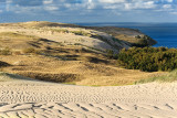
Kur�ių nerija (Curonian Spit) is a 98 km long narrow spit of sand dunes between Baltic Sea and Curonian lagoon. It's possible the highest coastal sand dunes in Europe, some up to 67 meters high. More information about geology of the area is available in Kursiu Nerija National Park website.
The whole Curonian Spit is listed as UNESCO World Heritage Site since 2000.
The dunes seen here are located between Juodkrante and Pervalka.
The photo taken at 17:51, about one and a half hour before sunset, facing north.
Copyright Linas Kardasevicius
| comment | |
| Barry S Moore | 28-Sep-2011 10:11 | |