


|
|
|
|
|
|
| |
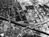
| 1960s | Paul Lowman |
Thanks to Brad King for supplying this image that was taken for his grandfather because he wanted a photo of his neighborhood. The new Airport Expressway is visible, along with the Miami River Canal, Okeechobee Road, the water tower at the northeast corner of Miami International Airport, the Triangle area bounded by South Royal Poinciana Drive, LeJeune Road, and NW 36 Street, etc.
Unless otherwise noted under the right bottom of the photo, all images are copyrighted by Don Boyd
| comment | |
| Guest | 21-May-2009 12:41 | |
| Rene | 15-Jun-2008 21:56 | |
| Sandra Sparksra | 19-Feb-2008 04:58 | |