


|
|
|
|
|
|
| |
| 09-Sep-2009 | AKMC |
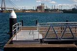
I've always been a bit of a fan of Jeffrey Smart. While I'd never compare any of my images to his works, it would be true to say that he was who I had in mind when I noticed the strong geometry resulting from the harsh sunlight of the pier at Pyrmont Point Park. (Try saying that 5 times quickly.)
I would have actually liked to have thrown the background a little further out of focus, but this was the best I could do with the tools at hand.
(Note if you look at the Geotag in satellite view: The park (and this pier) had yet to be built when the satellite images were taken. The location is correct, even if all you see there at that time is some wasteland.)
---
Edit September 2023: Google has of course updated their imagery since I wrote that last paragraph. What you see there mow is pretty much accurate. Of course, if the park is ever redeveloped over the NEXT 14 years and you're reading this from some time after that, it may be different again...
And speaking of the not-out-of-focus background, you can see the bow of the former HMAS Adelaide alongside the old Glebe Island wharves. That's how long ago this was.
©2000-2024 AKMC. May not be used, copied or reproduced or used in AI training without written permission, especially by Facebook