


|
|
|
|
|
|
| |
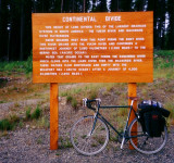
The Alaska Highway crosses the Continental Divide at the 1119 km mark. This is the ridge line that separates two of the largest river drainages in North America. Here the water to the east flows into the Rancheria River, then the Liard River and continues into the Mackenzie River in the Northwest Territories to eventually reach the Arctic Ocean after 4,200 kilometres (2,650 miles). To the west the Swift River joins Teslin Lake and the Teslin River which flows northwest to the Yukon River itself which ultimately empties into the Bering Sea after a total of 3,680 kilometres (2,300 miles).
Copyright Rolf Wahl Olsen 2011