photo sharing and upload picture albums photo forums search pictures popular photos photography help login
John Scurlock | all galleries >> Coast Mountains: British Columbia >> Lillooet Icefield > Upper Tchaikazan River, View SW
(MonTchaikazan021808-_233.jpg)
previous | next
18-FEB-2008

Upper Tchaikazan River, View SW
(MonTchaikazan021808-_233.jpg)

Lillooet Icefield

view map

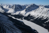
Note peaks along SW margin of the upper Tchaikazan River, from L to R:
Friendly Pk (L margin), Rim Mt, Moose Mt (L center, N face shaded), Spyglass Pk (R center).
Friendly: 51°2'42.5"N, 123°50'31.7"W
Rim: 51°2'00.3"N, 123°52'08.2"W
Moose: 51°3'24.3"N, 123°52'47.1"W
Spyglass: 51°4'39.0"N, 123°53'40.4"W

Canon EOS Digital Rebel XTi
1/1000s f/7.1 at 24.0mm iso400 full exif

other sizes: small medium large original auto
previous | next
share