


|
|
|
|
|
|
| |
| 09-MAY-2008 | |
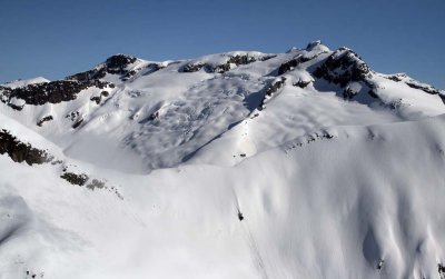
The view looks to the NW, across the Stafford River/S fork Wahkash Creek divide.
This area sits east of the head of Knight Inlet, about 10 km south of Mt Stanton.
It is drained by Brew Creek to the NE, Bear River to the SE, and Wahkash Creek to the W.
| Full EXIF Info | |
| Date/Time | 09-May-2008 09:24:46 |
| Make | Canon |
| Model | Canon EOS DIGITAL REBEL XTi |
| Flash Used | No |
| Focal Length | 28 mm |
| Exposure Time | 1/2500 sec |
| Aperture | f/9 |
| ISO Equivalent | 200 |
| Exposure Bias | |
| White Balance | |
| Metering Mode | partial (6) |
| JPEG Quality | |
| Exposure Program | aperture priority (3) |
| Focus Distance | |
Copyright 2002-2023, John H. Scurlock, Photographer/Pilot