Writing in my trip diary on a beautiful sunny morning in
the middle of nowhere. The view is to the southwest.
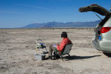
I car-camped next to the abandoned grade of the original transcontinental railroad (here it is a gravel road, out of view). This route runs east to Promontory, the site of the Golden Spike ceremony. My location is several miles northeast of Lucin. In the background is the Pilot Range; the snowy mountain is Pilot Peak. The little white thing above my head is the Lucin VORTAC.
My campsite is at the center of this Wikimapia view. There are no designated campsites here, only wide-open desert and the old railroad grade. In most places a person is forced to remain on the grade, as its shoulders are too steep (for a car like mine) to drive on. At one of the bridge by-passes it was possible to drive right onto the desert floor. I would not dream of leaving the elevated grade if the ground were wet, as the surrounding flat terrain---although innocent-looking---would be a gooey muck in which any two-wheel-drive vehicle would get hopelessly stuck.
Lion Mountain, mentioned in a comment, is the low, dark
mountain directly above my knee and the step stool.
Joe Tripod, my photographic aide in the field,
held my camera rock-steady for this photo.
|