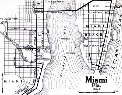
photo sharing and upload picture albums photo forums search pictures popular photos photography help login
Don Boyd | all galleries >> Memories of Old Hialeah, Old Miami and Old South Florida Photo Galleries - largest non-Facebook collection on the internet >> DOWNTOWN Miami, Bayfront Park and Port of Miami Historical Photos Gallery - All Years - click on image to view > 1919 - Map of Miami and Miami Beach with old street numbering system
previous | next
1919 Florida State Archives

1919 - Map of Miami and Miami Beach with old street numbering system

Miami, Florida


This map was obviously before they renumbered the streets sequentially north and south from Flagler Street which did not exist on this map. Note the designated boat race course in Biscayne Bay. Whatever happened to the Collins Bridge?


other sizes: small medium original auto
comment | share
Guest 12-Feb-2024 09:17
All due respect. Ms or Mr Billy Megaffey, if your a real person.... your grandfather George ,was a lier ,and a thief. every time I read an article displaying my grandfathers ,wailk with a free loaders name attached to it , and claiming his story , it makes me sick to my stomach. I will proudly challenge all lies being told. and I am currently rewriting the true facts of what I’ve study about our Overtown community history... NO LIES BEING TOLD HERE ..
N.Pressley 12-Apr-2013 17:27
Hello, see the MotorBoat Race Course in Bisc Bay? My Dad, a Master Mechanic would take me to see some of his buddie's racing, in engines he kept up to par, in the late 1940's & maybe even early 1950's. He taught engine intricacy to any young fellow willing to stay out in his lot and work in the sun while he answered questions on what to do next and identify what part they were looking at for the moment. Dad would be in the Shop and the hopeful mechanic would be out in the junkyard lot. As i remember the Racing, we usually sat in his truck on the east side of the Bay at what is now a Public Park. The boats are called Budweiser Boats now, but back then they were "Hydroplanes" or something like that. I will probably recollect the exact name about 3 a m. ha. Oldie goldie brain. Nita Pressley
Guest 11-Sep-2010 18:45
When my mother's family moved to Miami in 1912 the city went only as far west as Avenue D shown on the map! Look what nearly a century has done!
Don Boyd23-Nov-2009 14:41
Thank you very much, Billy. You're providing information that most of us didn't know about. Keep it coming if you can.

Don
Billy Mehaffey 23-Nov-2009 02:05
Found this little bit of info
Some Pre-Boom Developers of Dade County
By ADAM G. ADAMS
LeGro is given credit for promoting the purchase of bay bottom for Hibiscus and Palm Islands. The bulkhead around "Bull Island" now known as Belle Island was completed in 1914.
Billy Mehaffey 22-Nov-2009 23:43
That Island was known as Bull Island when the Collins Bridge was first built. The Collins bridge held the title of “longest wooden bridge in the world” It opened in 1913. the bridge was not as straight as shown on this map. The Venetian Causeway was built in 1926 to replace the basically three miles of wood bridge
Bob Sara 29-May-2009 01:42
Don, are you sure of the 1919 date on this image? This map doesn't show the County Causway at all, but the photo that follows this one in the set is of the County Causway, also dated 1919. Just wondering.
Ray06-May-2009 02:21
Anyone know what "Orange Ridge" was? Doesn't ring a bell for me. Could this be what the Orange Bowl was actually named after? I know it was originally named Burdine. But is there a connection between "Orange Ridge" and "Orange Bowl"? It would be funny if all this time it was named for something other than the fruit.

Why are those pilings still there? I've always thought they must be a heck of a danger to boaters at night.

Ray
Martha Pierson 06-Oct-2008 18:16
The Collins bridge is the Venetian Causeway. The Island is Belle Island. Dade Blvd
runs along the Collins Canal from the Venetian Cswy to 23rd ST where it turns into
Pinetree Dr.
Billy Mehaffey 27-Aug-2008 10:37
My great grandfather, George Cook built the Collin's bridge. Collins wanted to open up Miami Beach for development. There were a few hotels on the Beach but it still was a mangrove island. My grandfather Charles Cook told me the story about the problem of rats on the island. So they brought over cats to get rid of the rats. That worked well except now they had a cat problem. The feral cats were then bigger problem than rats. So what is next ? Dogs! Problem with this is , not enough dogs in Miami. They imported dogs from NY City. And dogs were big enough and slow enough to be hit with a rifle. I didn’t know how true this story until I read a story in the Miami Herald by the first Mayor of Miami Beach telling the same story
Jeff 15-May-2008 13:17
Correction... Alton Beach Avenue looks more to be Lincoln Road.

Bull's Island became the first of the Venetian Islands - the rest being dredged out of bay bottom. If the 1926 hurricane hadn't been so devastating to its builders, a Northward chain of islands (called the Garibaldi Islands on plat maps) would have been built mid-way from the Venetian Islands.

Ironically, only two "technically" still exist... "Pelican Island"... the group of pilings just to the South of the Julia Tuttle Causeway, and North bay Island - dredged and developed by the late Milton Steinhardt and his partners in the 1940's as part of the North Bay Island Development (North Bay Village).
Jeff 15-May-2008 13:10
By best guess, Ocean Beach Street is 5th Street, and Alton Beach Avenue is now 17th Street. Note how both the street and avenue ran East-West.

According to a past conversation with my good friend [Miami Beach-born] Aristole Ares (who was a civil engineer for Miami Beach for nearly 50 years), most all of the streets were renamed around the late 20's-early 30's.
Guest 13-May-2007 21:20
the collins bridge is the venetian causeway