


|
|
|
|
|
|
| |
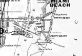
| 1925 | Courtesy of Alvin Lederer |
Thank you to Alvin Lederer for contributing this great old 1925 map of Miami.
Note that "South Beach" is south of 5th Street on Miami Beach and that "North Beach" is immediately north of Lincoln Road. Due to the value of the name somehow South Beach now extends north of Lincoln Road!
Causeway Island, future home of the U. S. Coast Guard, has not been developed by the time this map was published. Fisher Island was named "Peninnsula Island" at the time. It is amazing to see that the idea of a future Port of Miami on what became named as Dodge Island was conceived by 1925.
Please click on "original" below to see the image at the largest size.
Unless otherwise noted under the right bottom of the photo, all images are copyrighted by Don Boyd
| comment | |