I enjoy visiting new areas - especially ones with waterfalls I haven't seen. JC had suggested a visit to this area, and today seemed like a great day to do this. The forecast for the Upstate was sunny and low 70's. The Preserve is owned and managed by the SC Department of Natural Resources and more info can be found on this section of their site -
https://www.dnr.sc.gov/mlands/managedland?p_id=8
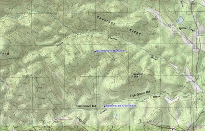
SCJack met JC and they met me at the intersection of Hwys 11 and 14. From there we continued south (actually west towards Lake Jocassee) on Hwy 11 for 4.5 miles and turned right on Oak Grove Rd. If you happen to be coming from the other way, Oak Grove Rd is just under 10.5 miles from the intersection of Hwys 11 and 25. Once on Oak Grove Rd, the small parking lot is a mile down the road on the left. Both JC and Jack had been here before - I hadn't. The only map I had to go by was this from my TOPO! software, so I assumed the trail would be the dotted line heading generally north. That old logging road is there and you can walk up it, but a very nice hiking trail has been cut and I would recommend it instead. It's at the east end of the parking area and well marked with a green gate. If you don't know how to read a topo map, elevation lines closer together indicate steeper terrain. Lines farther apart mean flatter lands. The trail is relatively flat as it heads east towards Squirrel Mountain, the cuts back to the west and north to stay flat and follow the unnamed creek shown on the map. The trail is close, but to the right of the dotted line and as you can see by the lines getting closer, you have to start going up. The trail switchbacks as it rises and goes through a few coves where toadshade trillium and bloodroot were blooming in abundance. The trail then reaches it's highest point at 001 on the map. The old road - the dotted line - also intersects here. To continue to the river and the 2 waterfalls, continue down the foot trail across the road. This meanders down the mountain and ends at the South Pacolet River near the word 'Pacolet' on the map. The river is more like a creek at this point, but you have to wade across and get your feet wet. It's only ankle to shin deep and 10-25' to the other side. You can see another dotted line on the map on the other side of the river. Climb up the bank to that old road, go left and it's a short distance to the 1st creek and waterfall. The map doesn't show this creek and it may be a mere trickle in very dry weather. You'll have to scramble up the left side of the creek for a closer view of the falls. The other waterfall is on the next creek down the road a short distance, but requires a steeper bushwack to get up to the falls. The hike to the waterfalls is over 6 miles round trip.