


|
|
|
|
|
|
| |
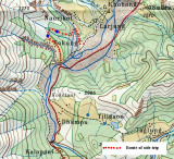
This walk takes you up to two lakes below the Dhaulagiri Icefall with great views of Nilgiri on a clear day. Follow the road south from Tukuche through Khobang and Larjung. When you come to the river crossing (the Ghatte Khola about 45 minutes from Larjung) follow the road up the side valley and cross the river on the road bridge. Then after about 10 minutes, a track heads up right and ahead, steeply through the trees. Keep climbing and the path eventually levels out and brings you to the first lake - Butharchho Tal. Follow the path on the right and continuing walking ahead with a gully on your left until you reach the crossing point. Turn left, cross the stream and continue on the path ahead. This will lead you to the second lake - Sekong Tal. You are now on the Dhaulagiri Icefall track and you can follow this down to the road. At the road you will see the suspension bridge across the Kali Gandaki on your left. Cross the river, turn right and walk on to Kalopani - about an hour away.
Copyright © 2000 - 2018; "thesilvertops" All rights reserved.