photo sharing and upload picture albums photo forums search pictures popular photos photography help login
Siggi Geirs | all galleries >> 2nd_day_of_christmas >> The 2nd day of Christmas 2009 > Almannagjá
previous | next
26-DEC-2009 Siggi Geirs

Almannagjá

Ţingvellir

The Ţingvellir area is a part of the North Atlantic rift system, almost entirely nested within the Reykjaneshryggur-Langjökull rift system.
It can be described as an area of sea-floor spreading, displaying the close association of crustal rifting and volcanism. Ţingvellir and the Great Rift Valley of Eastern Africa are the only sites on Earth where the effects of two major plates drifting apart can be observed.
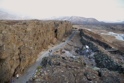
Almannagjá is 7.7 km long. Its greatest width is 64 m, and its maximum throw is 30-40 m. It marks the eastern boundary of the North American plate.
Its equivalent across the graben, marking the western boundary of the Eurasian plate is Hrafnagjá. It is 11 km long, 68 m wide and has a maximum throw of 30 m.
The Ţingvellir faults are believed to be the surface expressions of deeply rooted normal faults. The numerous fissures encountered on the valley floor are of similar origin.

Nikon D200
1/40s f/3.5 at 18.0mm iso400 hide exif
Full EXIF Info
Date/Time26-Dec-2009 11:31:39
MakeNikon
ModelNIKON D200
Flash UsedNo
Focal Length18 mm
Exposure Time1/40 sec
Aperturef/3.5
ISO Equivalent400
Exposure Bias
White Balance
Metering Modematrix (5)
JPEG Quality
Exposure Programprogram (2)
Focus Distance

other sizes: small medium large original auto
previous | next
share
mart senior30-Dec-2009 22:58
it certainly looks diffrent from when i was there this summer ...v
1moremile27-Dec-2009 13:31
Interesting photo and description. I'd be too scared to walk on it after reading what it is. V.
Type your message and click Add Comment
It is best to login or register first but you may post as a guest.
Enter an optional name and contact email address. Name
Name Email
help private comment