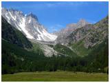
And we're off! Day one was our most difficult day with a total of 10.6 miles and a staggering 5675 feet in elevation gain and 3550 feet elevation loss (this is why most sane people opt for the clockwise route out of Champex rather than the counter clockwise route we took). We stopped in Val Arpette, about 45 minutes hiking from Champex, to take this picture of Fenetre Arpette, where we would be ascending. Fenetre Arpette is tied with Col de Fours as the highest point on the Tour Mont Blanc (TMB) at 8743 feet and we were lucky to have clear blue skies for the day (the guidebook advises this mountain pass only to be made in good weather). At the top of the pass the Trient glacier came into view and on our descent we saw it calve.