


|
|
|
|
|
|
| |
| 28-APR-2006 | |
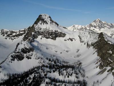
Chill Pk (Pt 7604) sits on Mt Winthrop's NW ridge, about one mile S of the Canadian border.
See also: http://www.pbase.com/image/61068207
Note Castle Pk in the R distance, four miles to the W across Castle Creek.
This view looks WSW.
Topozone link: http://www.topozone.com/map.asp?z=10&n=5428184&e=662709&size=l&datum=nad83
| Full EXIF Info | |
| Date/Time | 28-Apr-2006 06:42:09 |
| Make | Canon |
| Model | Canon PowerShot G6 |
| Flash Used | No |
| Focal Length | 11.2 mm |
| Exposure Time | 1/1250 sec |
| Aperture | f/4 |
| ISO Equivalent | |
| Exposure Bias | |
| White Balance | (-1) |
| Metering Mode | center weighted (2) |
| JPEG Quality | (6) |
| Exposure Program | |
| Focus Distance | |
Copyright 2002-2023, John H. Scurlock, Photographer/Pilot