


|
|
|
|
|
|
| |
| 30-JUL-2007 | |
Point Bonita is located at the northern entrance to the San Francisco Bay. The orignal name was in fact "Point Boneta" - a reference to the resemblance of the area hills to the hats worn by Spanish religious officials. (Early lighthouse plans are still labeled "Point Boneta.") In the early 1850's, when lighthouse construction began, there was still no marker at Point Bonita. In 1853 the steamship Tennessee ran aground just north of Point Bonita (at what is now Tennessee Cove). The clipper ship San Francisco struck the rocks of Point Bonita and sank in 1854.
In 1854, difficult work began on a lighthouse situated on the highest hill in the area - 260 feet above sea level. The point was very difficult to reach. The point was at the top of 50-foot cliffs, and the breakers from the Pacific side of the point are quite powerful. The first local contractor backed out of the job. A second firm completed the task - a California-cottage style dwelling, with a separate tower. The 56-foot high tower housed a fixed second-order Fresnel lens, the most powerful beacon of the San Francisco Bay. The lamp was lit for the first time on May 2, 1855.
As with many lighthouses of the area, fog was a major problem. High above the point, the lighthouse was often obscured by high fog. A surplus cannon was acquired from the Benicia Arsenal and a new keeper, Sgt. Edward Maloney, was hired to fire the cannon as a fog signal. The assignment proved very difficult, due to the frequency of fog in the area. Maloney once fired the cannon for three days, resting for only two hours. The cannon was also difficult to hear, and gunpowder was expensive. A fog bell with an automated clockwork was finally installed in 1856.
Difficulties in sighting the original light led the Lighthouse Service in the 1870's to move the light from the top of the hill to Land's End - the far end of the point itself. This is the most difficult area of Point Bonita to traverse, due to its steep cliffs and narrow paths. Huge breakers and rockslides were not uncommon. The first difficult steps in building a new lighthouse involved simply cutting a path to Land's End! A tunnel was cut through the rock to allow more direct access to the point. A new fog signal - a siren - was also built. The siren was washed into the sea by a storm in 1874, shortly after it began operation.
The new lighthouse was completed in 1877. The black lantern room and lens from the original tower were used, and the old tower capped. The new building was a one-story building with three rooms. The central room was built with heavy walls to support the tower. The entire structure stood 33 feet high.
Near the turn of the century, a new fog signal building at Land's End was built, and the Point Bonita Life-Saving Station opened. There were three such stations south of the mouth of the bay, but none on the north end. Boathouses were built on the ocean side near Rodeo Lagoon, and in Bonita Cove. The Life-Saving station would operate until about 1946, when the number of fast Coast Guard motor boats made the number of Life-Saving stations in the area unnecessary.
The San Francisco Earthquake of April 18, 1906 did no damage to the lighthouse, but toppled the old keeper's quarters of 1856. Lighthouse personnel noted that keeper Hermann Engel, whose family lived in the old keeper's house, remained at his post in the lighthouse during the quake. Other keepers helped the Engel family from falling building. A worried Engel was not informed until afterward that his family was safe. Even the old 1855 tower survived the quake. Up until this time, it still served as a useful daymark. In 1907, however, the Army removed the original tower. New residences were not built until 1908.
In the 1920's, Point Bonita's lamp was switched from a fixed to an osculating lens. An eclipser was installed within the lens which would block out the light at regular intervals.
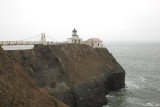
In the early 1940's a particularly violent storm washed out the narrow path between the lighthouse and the rest of Point Bonita. A wooden causeway was built to bridge the gap. this was replaced by a suspension bridge, which still stands. (At present, park personnel stand at both ends of the ridge to ensure that no more than five people are on the bridge at any given time.)
In the 1960's, the Coast Guard closed the station to the public. Compressed air horns had long replaced the old fog signals. By 1979, Point Bonita was the last manned lighthouse in California. The light was automated shortly afterwards. The station, while still maintained by the Coast Guard, was handed over to the National Parks Service as Park of the Golden Gate National Recreational Area. The Parks Service re-opened the station to visitors. The original second-order Fresnel lens still graces the tower.
DO NOT link, use, reproduce or alter this image or any part of this image Copyright held by Jim Weaver.