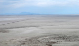
Interstate 80 is a thin dark line running from left to right close to the horizon and is 11 miles
(16km) away. Some semi-trailers on it are visible. And, amazingly, it is also possible to see the
Tree of Utah along I-80: look for a tiny tower above the black dot on the salt flats. The causeway
runs in a straight line all the way to Interstate 80. One might call this a "wide open space."
The causeway is at the center of this WikiMapia aerial image (click on any
rectangle): http://www.wikimapia.org/#y=40836152&x=-113604126&z=11&l=0&m=a&v=2 .
Photos of the Tree of Utah: http://www.pbase.com/listorama/pl_ut_tree .
.