


|
|
|
|
|
|
| |
| 14-OCT-2006 | Dave Beedon |
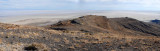
Shortly after leaving the summit, I had this view to the southeast of two terraces created
by ancient Lake Bonneville. From here my route took me to the little cone-shaped hill at the
end of the lower terrace, then around the corner of the upper terrace and back to my car.
The little hill is about 20 feet (6m) tall. A visit to the hill is shown in a few shots
beginning with this one: http://www.pbase.com/listorama/image/79193428 .
The angled line in the upper middle part of the image is a causeway linking Floating Island
with Interstate 80, about 10 miles (16km) distant. Access at its interstate end is controlled
by a locked gate. The causeway is at the center of this WikiMapia aerial image (click on
any rectangle): http://www.wikimapia.org/#y=40850177&x=-113608932&z=11&l=0&m=a&v=2 .
.
All images are copyright 1966 - 2023 by Dave Beedon (davebeedon AT comcast DOT net).