


|
|
|
|
|
|
| |
| 12-APR-2006 | Dave Beedon |
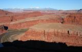
Just above the middle of the picture, where Shafer Trail disappears around
the tilted ridge, is Thelma and Louise Point. It is part of a level, light
green plateau that stretches to the right, ending at cliffs above the river.
Try to picture a huge blob of salt deep underground, pushing these
layers of rock up to form the tilted strata you see here.
.
All images are copyright 1966 - 2023 by Dave Beedon (davebeedon AT comcast DOT net).