


|
|
|
|
|
|
| |
| 12-APR-2006 | Dave Beedon |
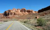
Up ahead on the right is the trailhead for Corona and Bow Tie arches.
At upper right, just below the long horizontal shadowy cliff, is the
grade for the rail line that runs down to Potash. Here it has just
exited the tunnel (out of view) mentioned in an earlier photo.
.
| Full EXIF Info | |
| Date/Time | 12-Apr-2006 10:50:20 |
| Make | Nikon |
| Model | D100 |
| Flash Used | No |
| Focal Length | 20 mm |
| Exposure Time | 1/640 sec |
| Aperture | f/7.1 |
| ISO Equivalent | |
| Exposure Bias | 0.67 |
| White Balance | (9) |
| Metering Mode | matrix (5) |
| JPEG Quality | (6) |
| Exposure Program | shutter priority (4) |
| Focus Distance | |
All images are copyright 1966 - 2023 by Dave Beedon (davebeedon AT comcast DOT net).