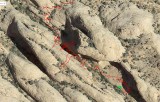
This image shows the effect of topography on the accuracy of GPS tracking during a hike in a deep canyon. The red line is the the route as plotted by the Map My Ride app in my iPhone 5. It starts at the green square. The phone was in the chest pocket of my shirt. Most of my hiking route was smooth, with little variation. If memory serves me well, the 180-degree turn at the start of the tracking is correct.
The wildest distortion occured just after starting the route, when I passed through a deep canyon. After leaving the canyon the tracking got markedly better (visible in other image). That other image shows the entire GPS track for this portion of the hike.
This was a part of a hike in the fins and canyons east of the trailhead of Negro Bill Canyon, near Moab, Utah. The top of the image is north.
The imagery is copyrighted by Map My Ride. This image is a cropped version of a screen shot. The area appears at the center of this WikiMapia aerial view.
|