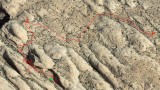
This overview image shows the effect of topography on the accuracy of GPS tracking during a hike. The red line is the the route as plotted by the Map My Ride app in my iPhone 5. I hiked from bottom left to upper right and carried my phone in the chest pocket of my shirt. Most hiking was smooth, with little side-to-side variation. In a couple of places I made a small loop or other variation. If memory serves me well, the 180-degree turn at the start of the tracking is correct.
I started in a wide, shallow canyon which produced minor route distortion. But shortly thereafter, where the canyon got narrow and deep, distortion became dramatic. Details of this portion appear in a companion image. After leaving the canyon and entering open terrain the tracking got markedly better. However, even out in the open, there was minor distortion here and there.
This was a part of a hike in the fins and canyons east of the trailhead of Negro Bill Canyon, near Moab, Utah. The top of the image is north.
The imagery is copyrighted by Map My Ride. Both images are cropped versions of screen shots. The area appears at the center of this WikiMapia aerial view.
|