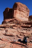
This is where I took my first rest break during a cross-country hike from Potash Road to the sandstone domes above Corona Arch. At lower center is my map case with print-outs of Google Earth screen shots---great navigation tools, far better than topographic maps.