| |
| 23-JUL-2013 | Dick Keely |
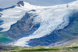
Skaftafell Glacier Tongue
Skaftafell National Park, South Iceland
Skaftafell is a preservation area in ųrµfi, southeast Iceland.
It used to be a manor farm and a national park, but has been a part of Vatnaj÷kull National Park since its establishment in 2008.
Before its inclusion into Vatnaj÷kull National Park, it measured about 4807 km2 (2884 mi▓), making it Iceland's second largest national park.
It is home to the valley Morsßrdalur, the mountain KristĒnartindar and the glacier Skaftafellsj÷kull (a spur of the Vatnaj÷kull ice cap).
The landscape is similar to some of the Alps, but it has been formed in thousands of years by different influences of fire (volcanic eruptions of ųrµfaj÷kull) and water (the glaciers Skeiarßj÷kull and Skaftafellsj÷kull), the rivers Skeiarß, Morsß und Skaftafellsß.
Volcanic eruptions under the ice-cap can give rise to j÷kulhlaups (glacial floods) which swell the Skeiarß river massively.
The last large j÷kulhlaup occurred in 1996.
Reference: Wikipedia
1/400s f/11.0 at 122.0mm iso400 hide exif
| Full EXIF Info | |
| Date/Time | 23-Jul-2013 14:18:04 |
| Make | Nikon |
| Model | NIKON D800E |
| Flash Used | No |
| Focal Length | 122 mm |
| Exposure Time | 1/400 sec |
| Aperture | f/11 |
| ISO Equivalent | 400 |
| Exposure Bias | |
| White Balance | |
| Metering Mode | |
| JPEG Quality | |
| Exposure Program | |
| Focus Distance | 42.170 m |
Copyright ® 2022 Dick Keely All Rights Reserved