


|
|
|
|
|
|
| |
| 12-JUN-2010 | Jola Dziubinska |
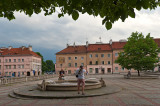
Mariensztat is located between the Vistula river and the Krakowskie Przedmiescie street.
The historical neighbourhood dates from the 18th century, when local nobleman Eustachy Potocki married Maria Katska and received the parcel of land as part of her dowry.
He established a jurydyka (a generic Polish term for a village right outside a royal city) and named the town Maryenstadt (town of Mary) after his wife's name, adding the German suffix "stadt" to please the Saxon king of Poland.
After World War II, the spelling was changed to Mariensztat, but this did not change the pronunciation.
The neighbourhood was razed to the ground during the Warsaw Uprising in 1944. Reconstruction work began in 1948, involving a complete redesign of the street plan and architectural appearance of the area.
Mariensztat became a model housing project under Poland's new communist authorities, and was the first part of the city to be completed in their ongoing reconstruction of Warsaw.
For the June Challenge - "urban and landscapes".
See the images of other pbasers participating in this challenge: http://form.pbase.com/viewtopic.php?f=16&t=44078%E2%80%9D%3C/a%3E
These images may not be used in any form without permission. Copyright © 2004-2023 Jola Dziubinska. All Rights Reserved.
Please login or register.