


|
|
|
|
|
|
| |
| 1932 | Florida State Archives |
Miami Municipal Airport was located on the east side of LeJeune Road (E. 8th Avenue in Hialeah, NW 42nd Avenue in Dade County) from the canal at E. 52 Street north to E. 65 Street (NW 106 Street to NW 119 Street in Dade County) and west of the railroad tracks separating it from All-American Airport/Master's Field. See other photos for aerial views of the airport along with diagrams showing street numbers. Typical of the way things go in Dade County, nothing is left of the airport and it is now occupied by the City of Hialeah Police Headquarters and auto garage along with a large UPS sorting facility.
The information below is from the National Weather Service webpage at: http://www.srh.noaa.gov/mfl/?n=floridahistorypage
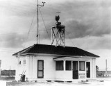
"A direct result of the 1926 Air Commerce Act, but not in operation until September 4, 1929, the Miami Weather Bureau Airport Station was first established at 11229 Northwest 42nd Avenue (near today's East 10th Avenue and 56th Street in Hialeah) at Miami Municipal Airport. Official psychrometric observations were not taken at that location until September 1, 1930. Dry and wet bulb thermometers, mounted on standard whirling apparatus, were exposed in an instrument shelter, over a sod covered plot, bounded 20 feet on the east and 30 feet on the west by paved roads. The location was about 13 miles northwest of central Miami. Biscayne Bay was about 7 miles to the east and Everglades about three miles west. Pibals (pilot balloons) began at the site on November 1, 1930, and rawinsonde observations (raobs) began on July 12, 1939, showing the importance of upper air observations to aviation. Ralph L. Higgs was the Junior Meteorologist in charge of the station. For many years, 1929 through 1975, the City of Miami had a WBO downtown and a WBAS at the airport."
Unless otherwise noted under the right bottom of the photo, all images are copyrighted by Don Boyd
| comment | |