


|
|
|
|
|
|
| |
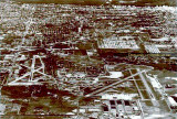
| Between 1945-1947 | Courtesy of MiamiSprings Memories |
Thank you to the MiamiSprings Memories Facebook group for posting this great old aerial image that I had never seen before. I cropped it, enlarged it and restored the original color to it to make it more presentable for this site. Please click on "original" below to see the image at the largest size on this site.
This great aerial photo depicts how the new Dade County Port Authority combined Pan American Field/36th Street Airport on the left with the U. S. Army Air Corps airfield on the right side. The two airports were separated by railroad tracks running east-west south of runway 9-27 on the left side (the tracks are visible in the photo). Since railroad property rights exceed any other property rights, the new Dade County Port Authority had to spend $2,000,000 to relocate the tracks to run south on the west side of LeJeune Road and then west just south of the combined airport and Perimeter Road. They also had to buy all the private property in between the two airfields where the new 20th Street Terminal was to be built in the late 1950's. We had a family friend who owned or leased a warehouse in that area and I remember when he had to move all of his business operations out of the warehouse because the Port Authority had bought the property for future airport use.
You can also see the western section of Grapeland Heights residential homes west of LeJeune Road (under the text on the photo) and just east of the south east-west runway. I remember driving through that neighborhood as a kid with my dad and/or aunt in the mid-1950's when people still lived there. I later remember blocks of empty homes after the airport bought them to add to airport property and reduce the residents' noise complaints. Eventually the homes were bulldozed to build the huge airport employee parking lot that sits there today.
Unless otherwise noted under the right bottom of the photo, all images are copyrighted by Don Boyd
| comment | |