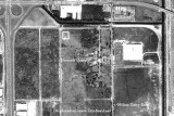
photo sharing and upload picture albums photo forums search pictures popular photos photography help login
Type your message and click Add Comment
It is best to login or register first but you may post as a guest.
Enter an optional name and contact email address. Name
Name Email
help private comment
Don Boyd | all galleries >> Memories of Old Hialeah, Old Miami and Old South Florida Photo Galleries - largest non-Facebook collection on the internet >> 1970 to 1999 Miami Area Historical Photos Gallery - click on image to view > 1970 - aerial view of Dressel's Dairy on Milam Dairy Road
previous | next
1970 SUS of Florida

1970 - aerial view of Dressel's Dairy on Milam Dairy Road

West of Miami International Airport view map


We can now see the dreaded development starting up west of the airport with a large building on the east side of Milam Dairy Road across the street from the dairy and another large building southwest of the dairy fronting the Palmetto Expressway. The entire area depicted is now paved over with warehouses and parking lots with few trees and little landscaping to prevent it from being yet another urban heat island to increase our temperatures even further. (See attached Geotag map)


other sizes: small medium original auto
comment | share
Don Boyd06-Nov-2009 13:16
Hi Steve, it looks right to me. The top is north. The Palmetto is west of Dressel's, Milam Dairy is east, but 36th Street is north, not south, and that's the way it was - Dressel's was south of 36th Street. There are numerous other photos on the site that show the same thing.

Don
Steve Z. 06-Nov-2009 12:27
I rember our father taking us there on Saturday afternoon for a treat at the ice cream bar. They had a small train we would ride in, it was a styled after the Seaboard Coast Line stream liner passenger train.

Steve Z.