


|
|
|
|
|
|
| |
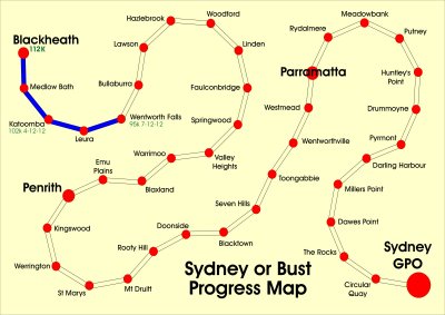
This isn't a serious scale or geographically rigorous map of the trek. Rather, it is a fanciful
record of progress along the course I have planned. Dates in green indicate the day that I arrived
at a place to complete a stage of the journey. From Blackheath until Parramatta, the course will
follow the traditional route of the Great Western Highway. I will leave the contemporary road
before it becomes a full time motorway at Penrith and revert to the "old" highway, which will offer
many more opportunities for good pictures.
From Parramatta, I shall follow the Parramatta River which ultimately flows into Port Jackson.
Toward the end of the journey the legs will be shorter simply because the opportunity for interesting
pictures should grow exponentially. Accordingly I am now planning on 20 legs instead of 16 in order
to allow space for good pictures
Distances assigned to a place in green are my best estimates of their final distance from the Sydney
General Post Office (i.e. GPO) as derived from various internet sources. These can only be
estimated, given that the information I find is determined in a variety of ways. Sometimes I find
"as the crow fies" distances. Sometimes I am offered a length of road between the places in question.
Images are subject to copyright. They may not be used without permission.