


|
|
|
|
|
|
| |
| 05-Aug-2012 | chris morton |
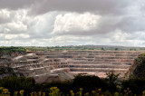
a view of Mells village I don't think you are meant to see, but equipped with 1:25000 OS map and ignoring danger signs, there 'tis.
The statistics are mind-boggling (at least for UK, doubtless small-fry for Brazil or China) eg 1.7 x 0.7km x 72m deep, designed to double; needing upto 20 million litres of water to drain it. All this hampered by silly planning conditions, for which removal is requested. See (4th item)
http://www.bgs.ac.uk/mendips/more_info/east_mendip_quarries_history.htm
copyright; please look at ORIGINAL size
| Guest | 11-Aug-2012 08:04 | |
| woody34 | 07-Aug-2012 23:16 | |
| Guest | 07-Aug-2012 23:04 | |
| Martin Lamoon | 07-Aug-2012 21:45 | |
| Phillip Normanton | 07-Aug-2012 19:31 | |