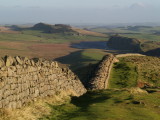
The Wall,ran for 80 Roman Miles,from Wallsend in the East(near Newcastle-upon-Tyne) to Bowness-on- Solway in the West.In this picture the Wall ran from the foreground,off picture to the rhs,coming back into view atop the crags in the middle distance,then across to the far distance,behind the modern farm buildings,climbing to the top of the craggy outcrop,left of centre,before descending past Housesteads fort,VERCOVICIVM(which is behind the second wood),to mount the shadowed cliffs in the distance,in the upper left of the image.
see http://www.nationaltrail.co.uk/HadriansWall/index.asp?PageId=1