


|
|
|
|
|
|
| |
| 15-JAN-2008 | |
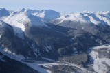
The view looks NW. Note that many of the peaks at center & R are unnamed.
The major drainage at upper center is Manatee Creek: 50° 39' 49"N, 123° 40' 24"W
The dark rocky summit at upper L is Wahoo Tower (50°36'41.00"N 123°45'56.20"W), a renowned peak in the Manatee Group.
For a detailed view of Wahoo Tower, see THIS IMAGE in the COMPTON NEVE gallery.
Copyright 2002-2023, John H. Scurlock, Photographer/Pilot