


|
|
|
|
|
|
| |
| 30-APR-2009 | |
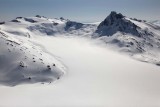
The peak at R (N 55° 54' 35.52", W 129° 37' 42.76") is unnamed, and sits 4 km S of Mt. Camber.
The peak at L/center (N 55° 55' 29.72", W 129° 35' 11.97") is estimated at 7800'+,
based on map contour analysis. It sits about 3 km SE of Mt. Camber.
The rocky summit at center/background is probably Pk 2246 (N 55° 54' 22.71", W 129° 30' 54.58" est.)
Photograph taken from a position east of the E margin of the Bromley Glacier.
Ref. map 103P-13
Copyright 2002-2023, John H. Scurlock, Photographer/Pilot