


|
|
|
|
|
|
| |
| 29-APR-2009 | |
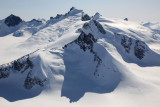
The summit of Pk 7810 is at far L.
This peak, along with Pk 7290, is part of an exposed ridge that lies about 16 km N of tidewater
at the terminus of the Dawes Glacier. It sits along the S margin of the S branch of the
South Sawyer Glacer.
Pk 7810: 57°37' 16", 132°47' 14"
Pk 7290: 57°36' 21", 132°46' 41"
| Full EXIF Info | |
| Date/Time | 29-Apr-2009 17:13:18 |
| Make | Canon |
| Model | Canon EOS 5D Mark II |
| Flash Used | No |
| Focal Length | 40 mm |
| Exposure Time | 1/1250 sec |
| Aperture | f/11 |
| ISO Equivalent | 400 |
| Exposure Bias | -0.33 |
| White Balance | |
| Metering Mode | matrix (5) |
| JPEG Quality | |
| Exposure Program | aperture priority (3) |
| Focus Distance | |
Copyright 2002-2023, John H. Scurlock, Photographer/Pilot