


|
|
|
|
|
|
| |
| 29-APR-2009 | |
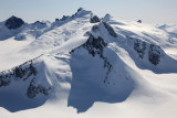
The summit of Pk 7810 is at far L.
This peak, along with Pk 7290, is part of an exposed ridge that lies about 16 km N of tidewater
at the terminus of the Dawes Glacier. It sits along the S margin of the S branch of the
South Sawyer Glacer.
Pk 7810: 57°37' 16", 132°47' 14"
Pk 7290: 57°36' 21", 132°46' 41"
Copyright 2002-2023, John H. Scurlock, Photographer/Pilot