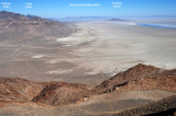
Graham and Cobb peaks are part of the Silver Island Range, as is Tetzlaff Peak. The WHITE DOT at
bottom is the site of my rest break self-portrait ( http://www.pbase.com/listorama/image/69793247 ).
Near it is the border between light rocks and dark rocks. The curving dirt road is the Silver
Island Backcountry Byway, which encircles the Silver Island Range.
This view of the "white dot" plateau and the gentle slope leading down to it,
seen in 2005, increased the curiosity I felt about the east side gully route.
.