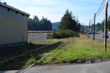
While driving north on US 101 in Oregon between Cape Blanco and Reedsport I noticed an unused railroad track next to the highway. In places it was overgrown with weeds and grass. I decided to photograph it so in the community of Millington (three miles south of Coos Bay) I stopped and took this picture. I shot this from the grade crossing on Isthmus Street. The view is to the southwest.
As I often do, I wanted to locate this site in Google Earth but finding it was a real pain---I could not find an overgrown track anywhere. But Millington is the only place that has a grade crossing, a building next to it, and a curving highway that divides. But aerial photography showed a well-used track that is not at all overgrown. What gives?
Street View imagery (viewed in mid-2018) is what settled tha matter: the details of the side of the building match those in my photo. But what about the condition of the track? It turns out that time played a trick on me, Some time after I took the picture the track was rehabilitated and put into use again.
My vantage point was at the center of this Wikimapia aerial view.
|