photo sharing and upload picture albums photo forums search pictures popular photos photography help login
Dave Beedon | all galleries >> Railroads >> Railroads: Nevada > Heading for Arnold Loop
previous | next
28-JUN-2005 20050628_6640

Heading for Arnold Loop

Cliffside, Nevada (northeast of Silver Zone Pass) view map


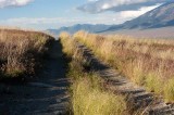
I was hoping to drive close to Arnold Loop, but the center-of-road grass kept getting taller and taller. When it got to be four feet (1.2 m) tall, I gave up and retreated. Turning around was a challenge on this narrow track---I had to back up for a while to find an "open" area into which I could turn around. Geo-tagging is approximate.

Arnold Loop is a horseshoe curve in the rail line connecting Salt Lake City with California, located about 20 miles northwest of West Wendover, Nevada and a few miles northeast of Silver Zone Pass.


.

Nikon D100
1/250s f/9.0 at 46.0mm iso200 full exif

other sizes: small medium original auto
share
Type your message and click Add Comment
It is best to login or register first but you may post as a guest.
Enter an optional name and contact email address. Name
Name Email
help private comment