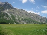
Sils im Engadin/Segl has an area, as of 2006, of 63.5 km2 (24.5 sq mi). Of this area, 27.8% is used for agricultural purposes, while 10.2% is forested. Of the rest of the land, 1.1% is settled (buildings or roads) and the remainder (61%) is non-productive (rivers, glaciers or mountains).
The municipality is located in the Maloja district. It consists of the village of Sils im Engadin/Segl which is made up of the sections of Sils-Maria, Sils-Baselgia, Fex, and Grevasalvas. Until 1943, Sils im Engadin/Segl was known as Sils im Engadin


Please login or register.