


|
|
|
|
|
|
| |
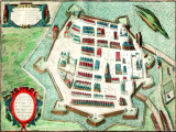
By Georg Braun & Franz Hogenberg, engraving ca. 1617.
Plans of Zamosc were drawn up simply and logically. The town had three squares, right-angled net of broad streets, big building allotments and temples for every religion.
It was a comfortable and modern town for 3 000 people, as well as a strong fortress to defend against enemies.
Zamosc Old Town is surrounded by a wall with seven bastions. These modern star-shaped fortifications helped the military defend the city against invaders.
All was planned from the very beginning. Morando marked out the outer line (2.5 km long) of the town and ordered to dig the moat (you can see it in the park now).
The dug out soil was used to make the embankments. As a result of all these earthworks Zamosc was surrounded by strong walls - the impressive bailey (brickwork) was 12 m high and 2.5 m thick.
Only three gates led to the city - each one with a drawbridge.
This perfect design influenced the Poland history - Zamosc was never conquered by any invading army.
These images may not be used in any form without permission. Copyright © 2004-2023 Jola Dziubinska. All Rights Reserved.
Please login or register.