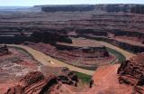
This view to the southwest is just a small part of what one sees from the main
overlook in the park. The Colorado River, which is 2000 feet (670m) below, flows
from upper left to lower right and up again. The land formation inside the bend
in the river is called the Goose Neck (NOT the same as Goosenecks State Park, which
is elsewhere). The road below is Shafer Trail, coming from Moab and Potash to the
left and going to Canyonlands National Park in the background. The raggedly-shaped
light coloring at lower left is an exposure of White Rim sandstone, one of the
many layers of rock formed millions of years ago.
When I first saw this scene in 2002 I fell in love with the Goose Neck and decided to try
to explore it on foot. So in 2004 I drove on Shafer Trail to get a close-up view of the
Goose Neck's north slope, believing that it offered the only route from the river to the
mesa. In 2006 I went there again for additional observation. These inspections gave me
the confidence I needed to plan a scramble up to the mesa. Studying of maps revealed
that the river is the only route of access, hence my ride on a jetboat in April 2006.
This mid-day photo does not do justice to the magnificence of the landscape. Other PBasers
have photographed this view in the morning or evening, when the lighting is much better.
.