


|
|
|
|
|
|
| |
| 12-APR-2006 | Dave Beedon |
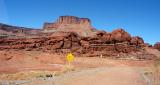
At the two yellow barriers ahead, Shafer Trail crosses a private road of the
mining company (we're on land owned by that company). It then turns right
into the gap just above the left barrier, and ascends another hill.
This shot was taken at the center of this WikiMapia aerial view (click on any
rectangle): http://www.wikimapia.org/#y=38490396&x=-109672587&z=16&l=0&m=a&v=2 .
.
All images are copyright 1966 - 2023 by Dave Beedon (davebeedon AT comcast DOT net).