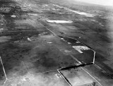
I think this one shows the land where I work today, Miami Dade Fire Rescue HQ. I think the building was built in the early 1970s as Eastern's System One computer facility. The land looks like it's already been cleared or developed as of this picture. So I guess something else was on this land before Eastern built the computer facility. I wish I could point to where I mean, but it's the white space to the left of the canal. NW 36/41 St seems to end right at that property in the picture. Most of the space to the left of that is now the Doral Golf Course. This prior use of the land could explain why I see a barricade along the canal that doesn't seem to fit the age of the building.
Is there a higher resolution version of this one available somewhere?