


|
|
|
|
|
|
| |
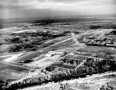
| APR-1942 | Florida State Archives |
From the state archives: "Pan American Field - Pan Am's 36th Street airport - the fore-runner of the present Miami International Airport appeared like this in April, 1942 when WWII was getting into full swing. Later modifications completely changed the appearance of the airport."
The view is looking southwest and is interesting to study. Okeechobee Road (US27) is at the bottom. LeJeune Road is on the left near the bottom. The Eastern maintenance base is at the northeast corner of the airport. Miami Springs appears mostly undeveloped north of the Eastern leasehold.
Unless otherwise noted under the right bottom of the photo, all images are copyrighted by Don Boyd
| comment | |