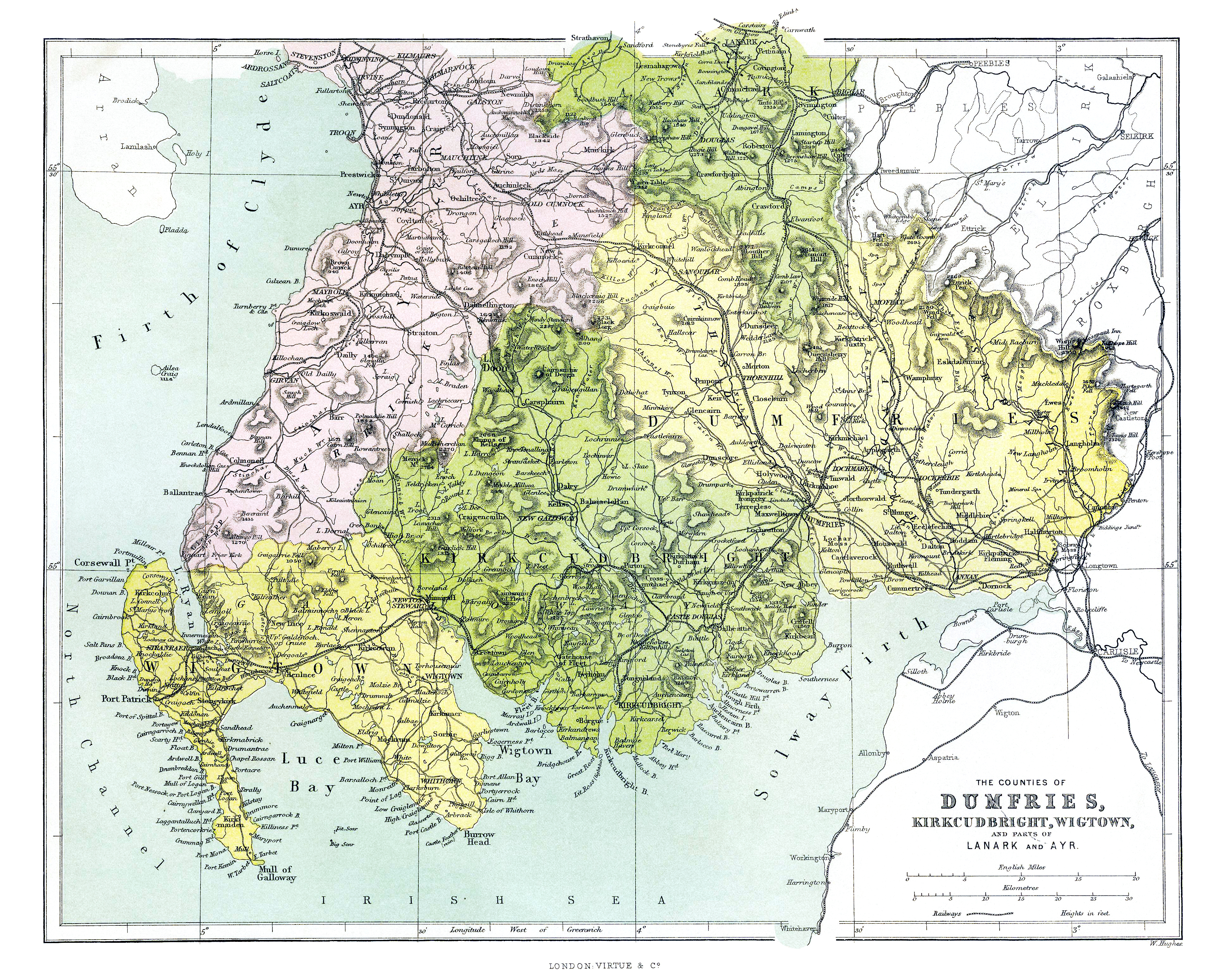
Dating of this map was incorrect by the seller; however, I've had some help from others.
Assuming that the map's author drew "what he saw" then, his map shows the line from Dumfries to Port Patrick (opened 12/3/1861) and also the line from Stranraer to Port Patrick (opened on 28/8/1862) but does not show the Stranraer Harbour Branch which wasn't opened until 1st October 1862.
In conclusion, and if all the clues add together to make a solution, the map was drawn between August 28, 1862 and October 1, 1862.
We owe our thanks to Alastair Macdonald for this fine piece of detective work :-)
I've done some significant retouching, but the map is not finished, yet. Eventually I'll correct the color miss-registrations so that the map will look better than it ever did.
I've had several inquiries about making this map available as a print. If you would like a print on 13"x19" matte paper of the finished map suitable for framing I will make it available for $20 delivered U.S.A. rolled in a tube for protection - very reasonable considering all of the time taken for the restoration - I'm over 100 hours already and looking at another 60-80 perhaps. The prints will be of fine art quality suitable for framing. The original coloring has faded. I did some restoration, or as close as I can get with Photoshop after over a century of aging, will be maintained including shading. Outside the U.S. - ask about additional postage fees, nothing else added.
Enjoy! :-)
DUMFRIES COUNTY 1862 PLACE NAMES
Ae Water
Annan
Annan River
Applegarth
Auchencass Castle
Auldgirth
Beattock
Barjarg
Black Esk
Black Lorg
Bridekirk
Broomholm
Brow
Burnswark Hill
Caerlaverock
Caerlaverock Castle
Cairn Water
Cairnkinnow
Canonbie
Carrel Old Kirk
Carron Bridge
Castle Lake
Castle Mills
Castlefairn
Closeburn
Cluden
Collin
Comb Head
Corrie
Courance
Craigbuie
Cravick Water
Cummertrees
Dalswinton
Dalton
Dalwhat
Dinwoodie
Dorknock
Drumlanrig Castle
Dryfe Water
Dumfries
Duncow
Dunscore
Durisdeer
Ecclefechan
Ellisland
Enterkinfoot
Eskdalemuir
Euchan Water
Evan River
Ewes
Ewes River
Fingland
Glencairn
Glencapte
Gleneslin
Gretna Green
Gurwald Linn
Halfmorton
Hallscar
Hart Fell
Holywood
Hoddam
Irvine
Keir
Kelton
Kilhead
Killoe Water
Killoeside
Kinnel River
Kinmount
Kirkbride
Kirtlehead
Kirkconnel
Kirkmahoe
Kirkmichael
Kirkpatrick Fleming
Kirkpatrick Juxta
Kirtle River
Kirtlebridge
Langholm
Little Dalton
Lochar Briggs
Lochar Moss
Lochar River
Locherbie
Locherben
Lochmaben
Meggat River
Mid Raeburn
Middlebie
Mille Water
Millholm
Milltown
Mineral Spring
Minnihive
Moffat
Morton
Mouswald
Muckledale
Nethercleugh
New Langholm
Nith River
Penpont
Powhillon
Queensberry Hill
Redhall
Ruthwell
St. Anns Bridge
St. Mungo
Sanquahar
Sark River
Shinnel Water
Skarr Water
Spa – 3 locations
Spango Water
Springfield
Springkell
Tarras River
Thornhill
Tinwald
Torthorwald
Tundergarth
Tynron
Wamphray
Wanlock Water
Wanlockhead
Wedder Law
Wester Hall
White Coomb
White Esk
Whitehill
Wind Fell
Wood Hill
Woodhead