photo sharing and upload picture albums photo forums search pictures popular photos photography help login
Bryan Murahashi | all galleries >> 2012 Adventures >> July 28 - Eight days and 77 Miles on the Pacific Crest Trail > The map of our second day on the PCT
previous | next

The map of our second day on the PCT

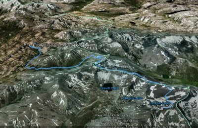
The link to the GPS plots for this 10.8 mile second day http://connect.garmin.com/activity/207968938

Elevation Gain: 848 ft
Elevation Loss: 2,649 ft
Min Elevation: 8,543 ft
Max Elevation: 10,843 ft


other sizes: small medium large original auto
share