Brian McMorrow
|
all galleries
>>
Europe
>>
Cyprus
>>
The Republic of Cyprus
>>
Choirokoita (Χοιροκοιτία)
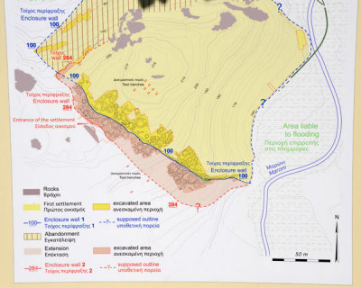
> Topographic map showing the locations of the circular huts in the settlement
previous
|
next
10-DEC-2011
Topographic map showing the locations of the circular huts in the settlement
Nikon D700
1/800s f/14.0 at 72.0mm iso400
full exif
other sizes:
small
medium
original
auto
previous
|
next
Images are Copyright Brian J. McMorrow
comment
|
share
Type your message and click Add Comment
It is best to
login
or
register
first but you may post as a guest.
Enter an optional name and contact email address.
Name
Name
Email
help
private comment